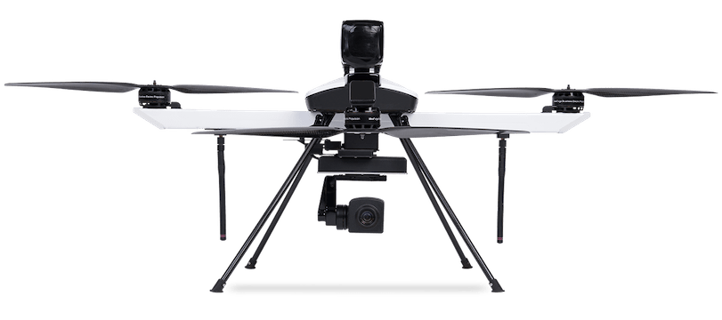
Q Series
Overview
Q Series is ideaForge’s small category VTOL Unmanned Aerial Vehicle (UAV) based on our best-in-class drone technology. It is one of ideaForge’s most economical and efficient drone built with tried-and-tested military design philosophies.
Q Series UAV can ideally be used for Surveying, Mapping, Security & Surveillance, Inspection, Photogrammetry, Traffic Management, Crowd Management & Disaster Relief.

Technical Specifications
 |
Endurance: 25 – 40 minutes @ MSL Range (LoS): 2 – 4 km Weight: < 3.5 kg Wind Resistance: Up to 20 knots or 36 km/h Max Operating Altitude: Up to 400 m AGL Max Launch Altitude: 3000 m AMSL Vehicle Size: < 1m x 1m |
Ground Control Station (GCS) Features

Fail-Safe Features
 |
 |
 |
| Multiple GPS for redundancy | Return home on low battery | Return home on high winds |
Applications
| Crime Control Monitor criminal activities and maintain law and order to ensure public safety |
Crowd Monitoring Monitor large public gatherings with fewer resources and increased effectiveness |
Forest & Wildllife Conduct zero-intrusion research and provide unprecedented protection to forest and wildlife |
Traffic Monitoring Get real-time intelligence for better traffic management |
| Precision Agriculture Maximize farm yield with highly targeted application of fertilizers, pesticides and irrigation methods |
Construction& Real Estate Plan and monitor projects and inspect hard-to-reach areas |
Industrial Asset Inspection Dramatically improve inspection of equipment for structural integrity to reduce maintenance costs |
Mining Optimize drilling and blasting, stockpile estimation and reduce environmental impact |
| Oil & Gas Improve site safety and reduce inspection and maintenance costs |
Power Transmission Inspect transmission towers and distribution infrastructure with higher speed, efficiency and safety |
Solar Energy Identify faulty panels and conduct preventive maintenance easily for maximum power output |
Wind Energy Access hard-to-reach systems easily and identify potential points-of-failure |
Há 40 anos ligando pessoas, facilitando negócios e vencendo desafios!


